


Climate Change
Share
Published 11:33 18 Oct 2021 BST
Updated 13:37 18 Oct 2021 BST

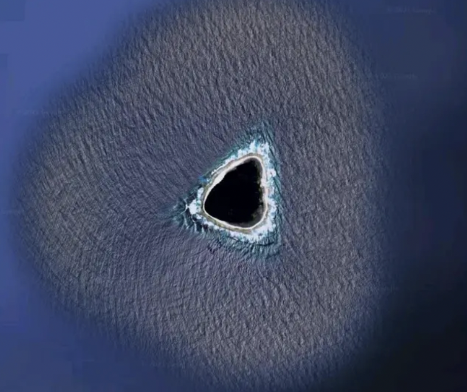 If you stare into it long enough, you get lost/Via Reddit[/caption]
The exact location of the island is currently unknown, which obviously adds to the mystery of the situation.
With a pitch-black centre, the mass appears to have waves crashing against its circumference. The interest is certainly in the blackened lagoon, leading people to question whether it's a cover-up of sorts.
Google Maps occasionally blacks out areas it's not permitted to show, hence why crazy theories are starting to circulate. But it could also be human error or potentially even a technical issue.
Users on Reddit, the home of many conspiracy theories, are eating it up.
One user said: "My first thought was that it's censored. It wouldn't make sense for a natural formation to be black like that in such a shallow, small atoll/island."
[caption id="attachment_294557" align="alignnone" width="928"]
If you stare into it long enough, you get lost/Via Reddit[/caption]
The exact location of the island is currently unknown, which obviously adds to the mystery of the situation.
With a pitch-black centre, the mass appears to have waves crashing against its circumference. The interest is certainly in the blackened lagoon, leading people to question whether it's a cover-up of sorts.
Google Maps occasionally blacks out areas it's not permitted to show, hence why crazy theories are starting to circulate. But it could also be human error or potentially even a technical issue.
Users on Reddit, the home of many conspiracy theories, are eating it up.
One user said: "My first thought was that it's censored. It wouldn't make sense for a natural formation to be black like that in such a shallow, small atoll/island."
[caption id="attachment_294557" align="alignnone" width="928"]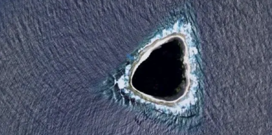 The lagoon's exact location is not known/Via Reddit[/caption]
And so the plot thickens.
Other users are throwing around the hollow earth theory, a missile silo, and even an inter-dimensional portal.
But not everyone is buying into the craze.
"OK so the real answer is the blue colour around the island is a painted-in color so the oceans look uniform in the maps," writes one party-pooper.
"Islands are added by erasing some of that blue to let the satellite image show through.
"Sometimes they do a sloppy job. So what you are seeing moving inward is: artificial ocean colour, real ocean with waves, beach, island.
"As for the shape, idk man islands come in all shapes and sizes I don't discriminate".
Anyone for a trip to an undisclosed island?
The lagoon's exact location is not known/Via Reddit[/caption]
And so the plot thickens.
Other users are throwing around the hollow earth theory, a missile silo, and even an inter-dimensional portal.
But not everyone is buying into the craze.
"OK so the real answer is the blue colour around the island is a painted-in color so the oceans look uniform in the maps," writes one party-pooper.
"Islands are added by erasing some of that blue to let the satellite image show through.
"Sometimes they do a sloppy job. So what you are seeing moving inward is: artificial ocean colour, real ocean with waves, beach, island.
"As for the shape, idk man islands come in all shapes and sizes I don't discriminate".
Anyone for a trip to an undisclosed island?
Explore more on these topics:

Climate Change

Climate Change

Climate Change

Climate Change
Major earthquake hits Japan days before new Baba Vanga predicted date
It had a magnitude recording of 5.5 Another so-called prophet has risen to steal Baba Vanga‘s thunder. MailOnline reported of a major earthquake striking Japan yesterday (July 3), two days before manga artist Ryo Tatsuki claimed a natural disaster would unfold in her graphic novel ‘The Future I Saw’. A magnitude reading of 5.5 was […]
Climate Change
1 year ago
Experts issue warning that Putin could attack the UK by blocking the sun
Taking inspiration from Mr. Burns of all people Russian leader Vladimir Putin may end up weaponising solar engineering technology against the UK, it’s been suggested. Intended to limit global warming, this fantastical tech would see aerosols deployed in the Earth’s atmosphere to reflect light back into the black expanse of space, yet experts are warning […]
Climate Change
1 year ago

Climate Change
David Attenborough says he is ‘approaching the end of his life’
Climate Change


