


News
Share
Published 09:13 18 Oct 2023 BST
Updated 09:13 18 Oct 2023 BST
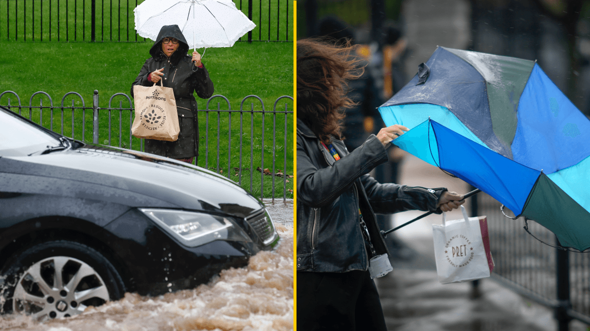
Brace yourself, Storm Babet is about to batter the UK in a four-day onslaught that will see much of the country hit with high winds and heavy downpours.
The second named storm of the season - after Agnes last month - will last until Saturday, the Met Office has warned and is expected to cause flooding, power cuts and travel disruption.
Yellow severe weather warnings are in place over the next four days for a vast swathe of the UK, covering already-saturated parts of Scotland, Northern Ireland, and northern and eastern England. An amber warning has been issued across central and eastern parts of Scotland, where up to 150-200mm of rain could accumulate.
The forecaster said people in the region can expect spray and flooding which may lead to dangerous driving conditions and some road closures for the duration of the yellow warning for rain, which comes into effect at 2pm and expires at 10am on Thursday. It also warned of a chance of fast-flowing or deep floodwater, and communities being cut off by flooded roads.
Strong southeasterly winds will also create dangerous conditions along the east coast of the UK, with large waves an additional hazard, the Met Office said.
Satellite images from NASA's Earth Observing System (EOSDIS) show Storm Babet moving over Spain and Portugal, where it is forecast to turn northwards and hurtle straight towards the British Isles.
The Met Office said spray and flooding may lead to difficult driving conditions and some road closures for the duration of the yellow warning for rain, which comes into effect at 2pm and expires at 10am Thursday.
"There is a small chance" that homes and businesses could be flooded, causing damage to some buildings, the forecaster warned.
It further suggested there is a small chance of fast-flowing or deep floodwater, and communities being cut off by flooded roads.
Flooding may lead to delays or cancellations of train and bus services and the Met Office says there is a slight chance of power cuts and loss of other services to some homes and businesses.
As the rain moves northwards it will stall across central and eastern parts of Scotland where the rain will become heavy and persistent from Thursday through to Saturday.
An Amber Severe Weather Warning for the area suggests up to 150-200mm of rain could accumulate in some areas of higher ground.
Rain warnings for every county in the Republic of Ireland were in place overnight, having come into effect throughout Tuesday.
A Status Orange rain warning is in place along Ireland's southern coast for counties Cork, Kerry and Waterford due to the risk of flooding, dangerous road conditions and possible wave overtopping at high tide amid heavy rain and strong gusts.
The advisory is due to expire at 1pm.
The Status Yellow rain warning for the rest of the country ending between 6pm-8pm.
A Met Office graphic shows that the east of the UK is set to be hit worst by heavy rain with more than 150mm possibly falling from Wednesday evening.
The area where most rainfall is likely to fall is in eastern Scotland from Aberdeen to Dundee.
Heavy rain is expected widely around Scotland with the central belt expected to see 100mm widely and possibly 150mm.
Then the area covering south eastern Scotland and north eastern England is likely to see 50 to 75mm widely and 100mm in hilly areas.
Northern Ireland: From Weds afternoon 15-30mm widely 75mm over some hills Risk of 125mm in the east
East Wales / West Midlands: From Weds morning 40-60mm widely 80mm for some hills
Central & North Scotland: From Weds night 50-75mm widely 100mm for some
North England and South East Scotland: From Weds eve 50-75mm widely 100mm for some hills
Related links:
Explore more on these topics:

News

News

News

News
Burnham to scrap Starmer’s digital ID scheme as ‘reset of priorities’ revealed
Millions were already against it Incoming prime minister Andy Burnham is expected to scrap Keir Starmer’s plans for digital ID cards in a “reset of priorities”, it has been revealed. As Burnham is set to enter Downing Street on Monday, he will reallocate unspecified resources from unpopular plan to helping with cost of living. Burnham’s […]
News
1 day ago
Andrew Tate and brother Tristan Tate arrested in US
The brothers face 59 combined charges Brothers Andrew and Tristan Tate have been arrested in the US in connection with an investigation headed up by UK police into a number of sexual offences. The Tates were arrested in Miami on Saturday and have been detained pending ongoing legal proceedings. In a statement, Bedfordshire Police said […]
News
1 day ago

News
New Sky alert as customers sent urgent security emails with steps to take
News


