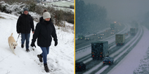
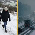
Freezing conditions are due to last until lunchtime on Wednesday
The Met Office has warned of slippery conditions on pavements and roads as icy weather is forecast to hit the entire country on Tuesday evening, with a severe ice warning issues in large parts of the UK and ‘thundersnow’ also possible.
Yellow weather warnings for ice are in place the length and breadth of the United Kingdom with only eastern Scotland, parts of Cornwall and coastal Wales seemingly safe from the frost.
Wintry showers are also predicted to land between 4pm on Tuesday and 11am on Wednesday, during which temperatures are widely forecast to drop to below freezing.
Snow has already begun to fall on higher ground, such as the M62’s trans-Pennine route in Yorkshire, and many urban areas including Manchester and London are likely to experience sleet showers as the cold weather comes in from the west.
Met Office spokesperson Richard Miles told JOE: “Most places will see temperatures below freezing tonight, except perhaps in coastal areas and the far west. The coldest parts of central Scotland could see down to -9°C.
“Several centimetres of snow might settle above 200 metres in Scotland, Northern Ireland, Wales and northwest England, but it is unlikely to settle in many low-lying areas.”
This weather system has travelled over from north of Iceland and is separate to the big chill that has devastated mainland Europe in recent days, but is nonetheless one to be very mindful of when heading outside.
“Ice amounts are not by themselves going to be a flooding hazard when melting,” the Met Office has assured.