









News

Share
Published 15:45 13 Nov 2026 GMT
Updated 15:45 13 Nov 2026 GMT
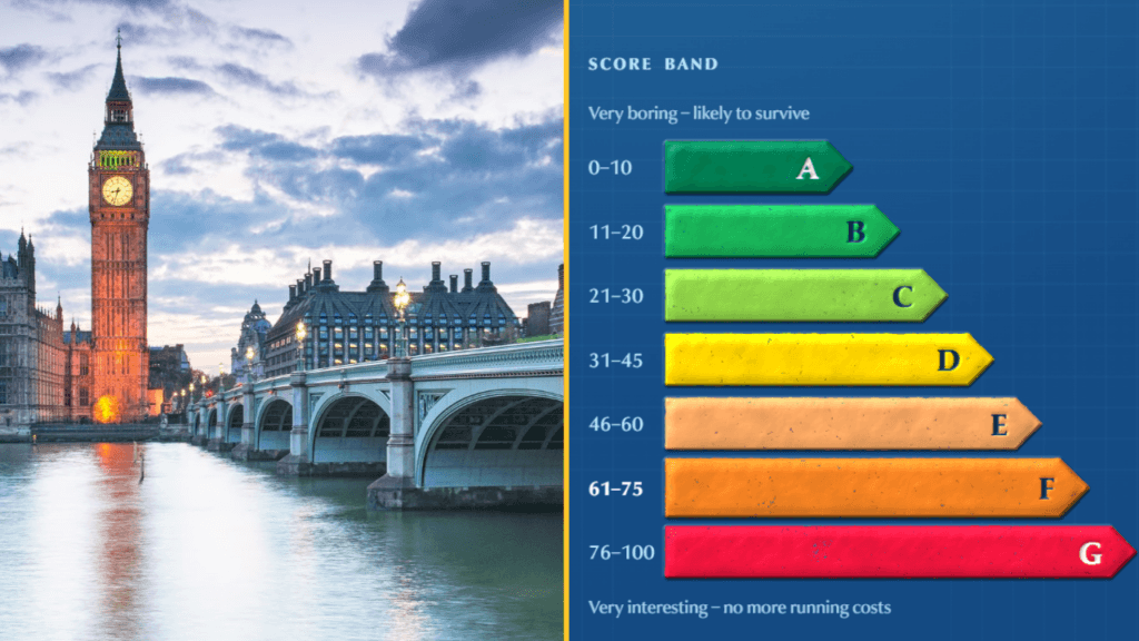
If the world were to end tomorrow, where would you want to be?
It turns out your postcode could make quite a difference.
A new interactive map has revealed which parts of the UK might be safest in the event of a national catastrophe, and which areas could find themselves in serious trouble.
And if you live in central London, the results aren't particularly reassuring.
The tool, called the Doomsday postcode checker, was created by Ukrainian developer Serhii Kashevko, who wanted to explore how different locations might cope with a major disaster.
According to Metro, the map grades locations from A to G, with A representing the lowest risk and G the highest.
It considers factors including proximity to military and nuclear sites, population density, access to hospitals and natural geographical barriers.
And while it can't actually predict the apocalypse, it offers an interesting look at which places might be more vulnerable.
If you're looking for somewhere to escape a hypothetical catastrophe, Northern Ireland might be worth considering.
According to The Independent, Fermanagh and Omagh ranks as the safest council area in the UK.
Its relatively small population, agricultural land and limited military infrastructure all contribute to its favourable score.
In Wales, Gwynedd comes out on top, helped by the mountains of Eryri, also known as Snowdonia.
The Shetland Islands are considered the safest location in Scotland, while Thanet in Kent ranks highest in England.
Generally, rural areas with fewer people and fewer strategically important sites perform better in the assessment.
Unfortunately for Londoners, the capital doesn't fare particularly well.
Central London is considered especially vulnerable because of its concentration of government buildings, major infrastructure and large population.
Westminster, home to Parliament and several government departments, is among the areas identified as particularly exposed.
But the most vulnerable council area overall is Gosport in Hampshire.
According to the analysis, there are 15 military or nuclear-related sites within 19 miles of the town, making it a potentially significant location in a major conflict.
Other areas near important defence facilities, including Plymouth and parts of Scotland close to naval bases, also receive unfavourable scores.
And the person behind the map has a rather personal reason for thinking about these risks.
Kashevko, a 30-year-old Ukrainian developer, told The Independent that his calculations were partly informed by the effects of Russian attacks on Ukraine.
Yes. The interactive Doomsday checker allows users to enter their postcode and see how their area scores.
However, there's an important catch.
The website describes the exercise as a thought experiment based on publicly available information, rather than a reliable prediction of what would happen in a real emergency.
The results also depend on the type of disaster involved, meaning a location considered relatively safe in one scenario might face very different risks in another.
The map comes amid renewed attention to emergency preparedness in the UK.
The government has encouraged households to keep basic supplies available in case of major disruptions, including bottled water, non-perishable food and battery-powered or wind-up radios.
So, while there's no need to start packing your bags for the Shetland Islands just yet, you can at least find out how your postcode fares.
Explore more on these topics:

News

News

News

News
Microsoft issues latest update on outage as some ‘improvements’ made
‘Improvements’ have been made, but disruption continues Microsoft has reported some ‘improvements’ in fixing a major service disruption that left users around the world unable to access parts of Outlook, Teams and Copilot. These improvements have been made mainly in North America and Europe, the tech giant has said. It added that some users may […]
News
2h
Kim Jong Un redesigns North Korea’s flag leaving behind old Soviet version
North Korea unveils new flag after 78 years. If news about North Korea, accompanied by the country’s familiar flag filled you with a rather old-fashioned sense of dread, things might be about to change. You can now feel that same dread with a slightly more modern-looking flag. That’s because North Korea has redesigned its national […]
News
2h

News
Active shooting ‘within walking distance of White House’ leaves five injured
News